Mapping and Design
Most of our Geographic Information System (GIS), Global Positioning System (GPS) and Computer-aided Design (CAD) services are conducted in support of our Landscaping, Natural Resources Assessment and Land Use projects. However, we also hire out our mapping, spatial analysis, field data collection and civil design services to clients or contractors. We provide these services for most any need, such as marketing, land management, development, infrastructure location-design, community planning, legal issues, and property survey.
Property Planning
- Registered Property Plats, Coordinated with Licensed Surveyors
- Property Planning (Existing and Planned Design Maps and Plats)
- Lawn and Garden Design
- Maps and Permitting for Development (GCPs)
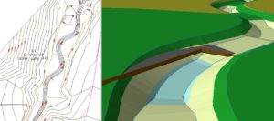
- Grading and Infrastructure Plans/ Stakeout
- Sediment and Erosion Control Plans, Stormwater Management Plans
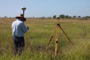
- GPS/RTK Survey and Spatial Data Acquisition
- Survey and Mapping of Land Features and Natural Resources for Planning and Assessment
- Sensitive Habitats and Ecosystems Delineation (such as Jurisdictional Waters – Streams and Wetlands)
- Soil and Water Contamination Modeling
Land Planning and Natural Resources Management
- Modeling of Biological and Natural Resources (such as forest types, geologic features, topography, water bodies, etc.)
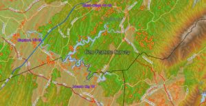
- Mapping and Spatial Analysis for Conservation Planning (including; Water Resources, Wildlife and Forest Management, Location of Sensitive Species and Habitats, External Stressors, and Comprehensive Management Plans)
- Naturalized Stream and Wetlands Design and Build
- Spatial Analysis (Water Quality and Availability, Soil Analysis, Land Use/Land Change, Viewscapes… to name a few)
- Wildlife Research and Habitat Use Modeling
- Jurisdictional Waters and Natural Feature Mapping
- Floodplain Studies
General Mapping Services
- Location Maps for Businesses (Marketing and Presentation)
- Business Marketing and Analysis (such as Proximity Maps, Community and Population Demographics)
- Multi-sourced Data (Imagery and Analysis using data from Aerial Photography, Satellite, Lidar, 3D Relief, Elevation Contours, GPS, etc.)
- LIDAR and Aerial Photogrammetry Acquisition and Analysis
- Community/ Watershed to Regional Scale Analyses
- Risk/Benefit Analysis (Natural Resources, Business, Socio-Economic)
- Presentation Mapping (unlimited themes)
- Site Specific Data Acquisition with GPS/RTK